The tectonics of Indonesia
are very complex, as it is a meeting point of several tectonic plates.
Indonesia is located between two continental plates: the Eurasian Plate (Sunda
Plate) and Australian Plate (Sahul Shelf); and between two oceanic plates: the Philippine
Sea Plate and Pacific Plate. Then, western or eastern part of Indonesia that
have more active plates activity?
Order of tectonic in the western part of Indonesia shows
the pattern of the tectonic that relatively simpler than the eastern part of
Indonesia. The simplicity of tectonic structure is influenced by the presence
of the Sunda Shelf that relatively stable. Striking dynamic movement only
occurs in Borneo rotation and stretching of Makassar Strait. This can be seen
in the pattern of distribution of West Indonesian subduction path . Thing that
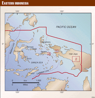
make eastern Indonesian geological structure more complicated is island arcs
that bounded by the ocean with a depth of thousands of meters with trenches in
a curved arc that exists between different sharp. Tectonically , eastern
Indonesia is the location of the meeting of three tectonic plates, the Pacific
Plate moves from east to west, the Australian Plate moving from the southeast
to the northwest and the Eurasian Plate are moving from northwest to southeast.
The crash among three tectonic plates produces a complex pattern that spreads
from the island of Sulawesi, Maluku to Irian Jaya,
In the
northern part of eastern Indonesia , the Pacific plate crashed into the west
and south of Indonesia . The enormous pressure because of the movement of three
earth plates : the Eurasian Plate , the Indian - Australian plate and the
Pacific plate that caused the interior of the Earth's plates of the Indonesian
archipelago is divided into small parts between the crust that move against
each other that limited by active faults . While the western part of Indonesia
is relatively stable compared to eastern Indonesia , therefore the islands are
larger than those in the eastern region of Indonesia .
In the western
region of Indonesia regularity tectonic lines clearly visible. Diping speed
of the Indian-Australian continental plate in an average of 7.7 cm / year,
relatively oblique dip in parts of Sumatra. This oblique diping produce
trenches in the sea and on the land resulted in the Bukit Barisan mountains. In eastern of Indonesia, Pacific Ocean
moving at an average speed of 8 cm / year (Sudrajat, 1997) against the Eurasian
Plate from the east, so that ripped the earth's crust in Sulawesi with the
formation of fragment slides: fault Pulokoro, fracturing Matano, and fault
Sorong, etc. Maluku Sea is a clash between the plates of Eurasia-Pacific-the
Philippines. This clash led to the formation of double subduction. Sangihe arc
dip to the west reaches a depth of 650 km, and Halmahera swooping east to reach
a depth of 300 km.
The area
surrounding the West Southeast Maluku and Southwestern Maluku is a high
earthquake-prone areas. The complexity of the geological conditions and the
mixing of subduction of the India-Australia , the Pacific, the Eurasian and the
Philippine plate cause the seismicity is more complicated. Whereas the
earthquake and tsunami recorded history that had ever happened records that
there are 174 tsunamis in Indonesia in 1629-2014, approximately 60 percent
occurred in eastern Indonesia.
So, from
the data we can conclude that Eastern
part of Indonesia has more active plates activity as the location that lies
among three active plates.


No comments:
Post a Comment